Placer
North Meadow Creek Gold #10
📍 Madison County, Montana
- Au
- Ag
- Gems
$16,500
20-Acre Placer Mining Claim · Sierra County, California
$6,500
All BLM & county filing fees included. Typical transfer completes in 2–3 weeks.
“Ayers Claim” 20 Placer Mining Claim
The Ayers Claim is a past producing gold placer mining claim, measuring 20 acres, located next to the striking Northern Sierra Buttes in the beautiful Tahoe National Forest! Situated at the junction between two rivers, the Ayers Claim placer double-dips into two gold-rich streams! The Church Creek upon which the claim sits can be panned and mined year round, but it’s adjoining partner only flows seasonally in spring and parts of summer. Some miners might see this as a hindrance, but more enterprising miners will find the variability of the dry times to be a unique stroke of luck.
Known to be a gold-rich valley, the terrain surrounding the Ayers Claim is known to push gold down to Sierra City via its many rivers stemming from the Salmon Lakes, Stag Lake, and the aptly-named Gold Lake herself. The gold in the mountains, once captured by lode mines like the Lone Wolf Group, the still fiercely-guarded Monarch Mine, and the wonderfully well-understood Jamison Mine, now only reveal themselves from yearly rain and snowfall. Quaternary glaciers form new tills and moraines as they make their way down the mountains, using the weight of gravity and tons of ice to scrape off new chunks of gold and other minerals from the mountain, where melting ice and snow trickle and roll them into the local creeks, rivers, and lakes!
Because of this process, gold seems to keep springing up in these streams and lakes! Constantly renewing itself every year with fresh water and minerals, the Ayers Claim sits on coveted ground! Finding a claim on the local rivers can be hard, and being such a short distance from the beautiful Gold and Salmon Lakes, the Ayers Claim is the perfect place to camp close to the refreshing waters and fishing available on the lake while keeping distance from the summer crowds. Of course, being so close, you could rent one of the many cabins up at the lake and come down to your private claim to mine! The choice is yours…
But that’s not all. Wild deer can be seen tip-toeing through the claim if your eyes are sharp. And if the nights up in the Sierras become a little too cold, following the Gold Lake Highway South to Sierra City will provide you with warm beds, food, and drink as quick as a 15-minute drive!
| Type of Claim | Unpatented Placer; CA106713089 |
|---|---|
| Size of Claim | 20 Acres |
| Commodities | Gold. |
| Past Production | Yes. |
| State, County | California, Sierra |
| Accessibility | Developed Mountain Highway |
| Deposit Type | Quartz-type, glacial deposits |
| Cell Phone Reception | 4GLTE All Networks |
| Relics | No. |
| NE | 39.649763°, -120.631546° |
|---|---|
| NW | 39.649741°, -120.636206° |
| SE | 39.647928°, -120.631546° |
| SW | 39.647933°, -120.636208° |
| Monument | 39.648861°, -120.635116° |
|---|
Corner and monument coordinates (WGS84) read from the claim’s official Google Earth KMZ boundary file.
| Type of Claim | Unpatented Placer Claim |
|---|---|
| Size of Claim | 20 Acres |
| Commodities | Gold, Silver |
| Width | N/A |
|---|---|
| Ore Body Type | Quaternary Glacial |
| Development | Prospected |
| District Name | Northern Sierra Buttes |
| Operation Type | Surface Placer |
|---|---|
| Development Status | Inactive |
A mining claim gives the holder the right to mine on mineral-rich land that belongs to the federal government. Mining claims are a tangible asset and show proof of all interests in minerals in the area. They can be bought, sold or used as collateral, just like any other piece of real estate.
A mining claim can be sold, traded, leased, gifted, willed, used as collateral or transferred in part or in its entirety just like any other real property using a quitclaim deed which is a recordable conveyance. Questions about the transfer process can be answered by contacting us anytime. All fees and paperwork current and assessment fees are paid through Sept. 1st 2026.
It’s easy to maintain this claim after purchase:
If you have less than 10 claims, you are eligible to file a small miners exemption and the cost to maintain is only $10 per year per claim. Contact us anytime for help maintaining your claim. Full details on maintaining your claim can be found on the BLM’s website here.
The filing and transfer service will be done on your behalf and completed within 48 hours after purchase. Buy this claim now with the Paypal™ link below.
Now you can buy mineral rights online and we handle all the dirty work! Contact us anytime to pay by cash or check.
$6,500
Cash Price
Make a one time payment and get new mineral rights transferred in your name quick and easy.
Purchase… and other options available. Contact us to make an offer and more. See financing full terms.
Contact UsAfter your purchase is complete you will be requested to fill out our new claim owner form with your name/address or add any additional claimants you want on the claim.
You’ll get digital copies of your COL and Map of Location in to your claim(s) will be delivered via email via PDF format as well as Google Earth™ KMZ map file with your claims discovery, corners and points of interest.
We handle all the filing and transfer services on your behalf. Expect to get official stamped/recorded copies of your paperwork mailed to you from the Sierra County Recorders Office and the California Bureau of Land Management officiating you as the new claimant within 10 days of purchase.
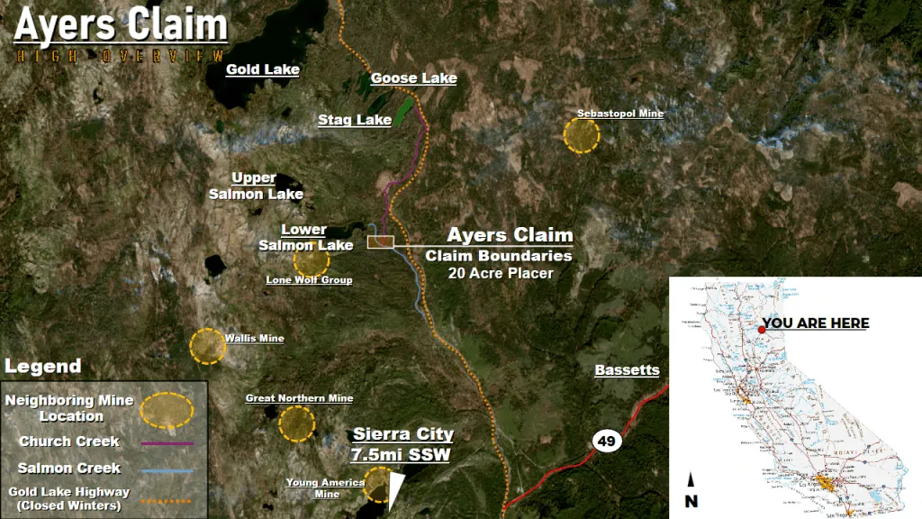
The Ayers Claim sits roughly 7.5 miles north-northeast of Sierra City along the Gold Lake Highway corridor, a well-traveled recreational route through the Lakes Basin area of the Tahoe National Forest.
Plan summer and early fall visits for the most reliable road access; check current Forest Service conditions before making the trip in shoulder-season months.
The Ayers Claim is a placer mining claim located in Sierra County, California, one of the richest gold-producing counties in the Golden State. Sierra County has a storied mining history dating back to the California Gold Rush of 1849, and continues to produce gold for recreational and small-scale miners today.
Primary and secondary commodities on this claim include:
Sierra County is underlain by a complex assemblage of metamorphic and volcanic rocks that host extensive gold-bearing quartz vein systems. Over millions of years, erosion of these lode deposits has created rich placer accumulations in the county’s streams and rivers. The Ayers Claim targets one of these proven placer environments.
The Ayers Claim is situated in California’s legendary Mother Lode country. The claim area is characterized by:
This claim offers an affordable entry point into California gold mining, with proven geology and a rich district history supporting its potential.
Sierra County is one of California’s most historically significant gold-producing regions. The county was established during the California Gold Rush and has produced gold continuously for over 170 years. The district encompasses the northern portion of the Mother Lode belt, with numerous historic mining towns including Downieville, Sierra City, and Alleghany.
The county’s geology consists of slate, greenstone, and granitic rocks that host extensive gold-bearing quartz veins. Placer deposits derived from these lode sources have been worked by prospectors using everything from gold pans to hydraulic monitors. Modern recreational miners continue to find color in the county’s streams and gulches.
The Ayers Claim sits within this proven mineralized environment, offering both the security of a historic district and the potential for new discoveries.
The Ayers Claim is a surveyed 20-acre placer claim located in Sierra County, California, at the foot of the Northern Sierra Buttes in the Tahoe National Forest. Situated on Church Creek, the claim benefits from year-round water and sits within a short distance of Salmon Creek as well.
Sierra County is one of California's richest gold-producing regions. The terrain surrounding the claim pushes gold down toward Sierra City via drainages stemming from Salmon Lakes, Stag Lake, Goose Lake, and Gold Lake. Historic lode mines in the district — including the Lone Wolf Group, Sebastopol Mine, Wallis Mine, Great Northern Mine, and Young America Mine — once captured this gold in the mountains; today, annual rain and snowfall release new material into the local creeks and rivers. Quaternary glaciers continue forming new tills and moraines, scraping fresh minerals from the mountain bedrock and depositing them into the watershed.
The claim sits within easy reach of Gold Lake and Salmon Lake, making it an ideal base for prospectors who want to camp near refreshing mountain water and fishing while staying clear of summer crowds. Cabin rentals are available at the lakes for those who prefer a roof over their heads.
Satellite view of the claim area. Click the pin for a quick summary.
Approximate district-level location shown to protect the exact claim boundaries. Contact us for precise coordinates and a guided map.
Explore other active lode and placer claims.